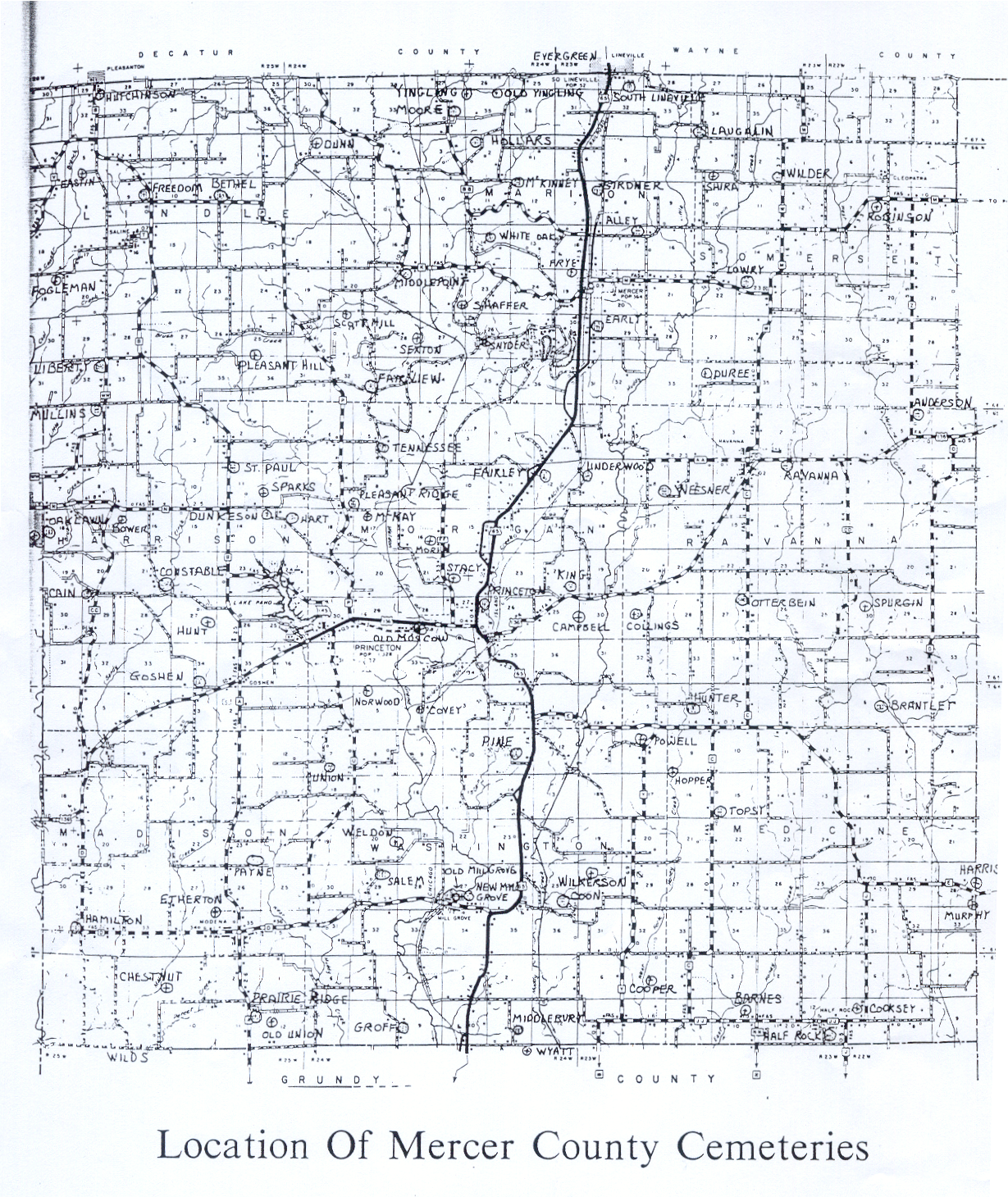
Mercer County MO Cemeteries
 |  |
Cemeteries with an asterisk (*) are included in the USGNIS. Two asterisks (**) indicates a cemetery in the GNIS database not included in local records.
Delores Rowlands provided the list of cemeteries and their locations, and Phil Stewart provided the directions.
Range- Section | ||||
| Alley Cemetery* | Marion | T66-R23-S17 | From Princeton, go north on highway 65, past the town of Mercer (approx 7 miles) to the first gravel road to the right (approx 1 mile north of Mercer). Turn right (east). The cemetery is approximately one mile east on the left (north) side of the road. | |
| Anderson Cemetery* | Ravanna | T65-R22-S05 | From Ravanna, go east on highway 136 approximately three miles and turn left (north) on blacktop Z. The cemetery is located on on the right (east) side of the road at the first crossroad. | |
| Barnes Cemetery | Medicine | T63-R23-S10 | From Princeton, go south on highway 65 for approximately two miles and turn left (east) on blacktop E. Follow E approximately four miles to blacktop C and turn right (south). Go south on C approximately seven miles to where it intersects with blacktop JJ and turn left (east). Go east approximately one mile. There will be a sign for "Barnes Cemetery" on the left side of the road and a gate allowing access to a farm lane. Follow this lane (actually a very old road) through the trees for approximately 1/2 mile to the cemetery. | |
| Bethel Cemetery | Lindley | T66-R25-S11 | Approximately 12 miles northwest of Princeton. From Princeton, go west on highway 136 to Route P and turn right (north). Go north on Route P for 8 1/2 miles to the first blacktop road to the left (west). Go west one mile to the church and cemetery. It is on the right (north) side of the road. | |
| Bower Cemetery | Harrison | T65-R25-S17 | This cemetery is located about 1/2 mi west of Zion Church, in section 17, Harrison Township, Mercer County. From Princeton, go west on highway 136 approximately eight miles to blacktop CC. Turn right (north) and go north approximately six miles to the intersection with blacktop N. The cemetery is approximately 1/4 miles southeast of this intersection. | |
| Brantley (Patterson) Cemetery* | Ravanna | T64-R22-S6 | From Princeton, go south on highway 65 for about two miles to blacktop E. Turn left (east) on blacktop E and go six miles to the gravel road to the left at the curve. There is a sign at the corner directing to Brantley Cemetery. Go east on the gravel road a little less than two miles. There will be a sign on the left for Brantley Cemetery. Cross the cattle guard and follow the gravelled lane up the hill and to the right. The cemetery is at the end of the lane. | |
| Brummett (Prairie Ridge) Cemetery | Madison | T63-R25-S11 | Just off Route A, a mile north of Grundy County line | |
| Cain Cemetery | Harrison | T65-R25-S20 | From Princeton, go west 9 miles on highway 136 to blacktop "CC". From Bethany, go east 18 miles on highway 136 to blacktop "CC". (Note: there is a blacktop "CC" that goes south from highway 136 in Harrison County. Do not turn there. Turn north on "CC" and proceed 4 miles to Fairview Place which is a gravel road that goes to the left (west). There is a small sign adjacent the blacktop. The gravel road will almost immediately fork into three different roads. Stay on the one to the far left. The cemetery is approximately 1/4 mile ahead at the end of the gravel road. | |
| Campbell Cemetery (McMahon) | Morgan | T65-R24-S25 | Campbell Cemetery is located on the western line of section 30 of Morgan Township of Mercer County, approximately two miles east of Princeton. It is on private property, approximately 1/2 mile south of highway 136, and is not accessable by vehicle. | |
| Chestnut Cemetery | Madison | T63-R25-04 | Located in the extreme southwest corner of Mercer County. From Modena, go south just over one mile to the second road to the right (west). This road will quickly turn to a semi-gravel/dirt farm road. Continue west one-and-a-half miles. The road will turn to the south at the top of a hill. The cemetery is located approximately 1/4 mile north of the road in a pasture/timber area and is on private property. | |
| Collings (Collins)Cemetery* | Ravanna | T65-R23-S29 | From Princeton, go east on highway 136 to the first gravel road to the right. Go south approx 1/2 mile. The cemetery is on top of the hill west of the road. | |
| Constable Cemetery | Harrison | T65-R25-S21 | From Princeton, go east on highway 136 approximately five miles and turn right (north) on blacktop B. Go north approximately two miles to the first gravel road to the left (west). Go west one mile. The road will "Y" off. Go the the right (north) and go to the first house on the right. The cemetery can be seen from the driveway. It is approximately 1/4 mile from the road on private property. | |
| Cooksey Cemetery | Medicine | T63-R22-S07 | From Princeton, go south on highway 65 approximately two miles to blacktop E and turn left (east). Follow blacktop E approximately 10 miles to blacktop J and turn south. Follow J to the intersection with blacktop JJ. The cemetery is located behind a house at the southwest corner of the intersection. | |
| Coon Cemetery | Washington | T64-R24-S25 | From Princeton, go south on Highway 65 approximately five miles to the fifth road to the left. This is actually part of the old highway 65. There is a sign for the cemetery at the intersection. Turn left. The road will angle south-east, then straighten to the south. Go approximately 3/4 of a mile to the gravel road intersection. Turn left and proceed east approximatley 3/4 of a mile to the next "T" intersection. Turn left (north). The cemetery is at the end of this road. | |
| Cooper Cemetery | Washington | T63-R23-S05 | Cooper Cemetery is located in south-central Mercer County, a mile-and-a-half north of the Grundy County line and approximately four miles west of the village of Half Rock. Little remains of the cemetery that is on private property. It is approximately 1/2 mile from the nearest road and is inaccessable by vehicle. | |
| Covey Cemetery | Morgan | T64-R24-S04 | From Princeton, go south on highway 65 to the first gravel road to the right (west). Follow this road and turn right at the first intersection, then proceed for approximately three miles. The road will turn west, then back south. The cemetery is on the right (west) side of the road just before the gravel ends. | |
| Dunkeson (Dunkerson) Cemetery | Harrison | T65-R25-S13 | From Princeton, go two miles west on highway 136 to blacktop P and turn right (north). Follow P approximately two miles to the first gravel road to the left. Follow this gravel road to the first intersecting road, and turn left again (west). The cemetery, which hardly remains, is on the left (south) side of the road just past the intersection. | |
| Dunn Cemetery (Peterson) | Lindley | T66-R24-S06 | From Princeton, go one mile west on highway 136 to blacktop P and turn right (north). Follow route P approximately nine miles to where the blacktop makes a sharp turn to the left (west). A gravel road will continue north. Go north less than a mile to the first road to the right (east). Follow this road just over one mile to the first road to the left (north). Go north approximately 1/4 of a mile. The cemetery is in a field on the right (east) side of the road. | |
| Duree Cemetery* (Pickett) | Somerset | T66-R23-S34 | From Ravannah, go north on blacktop M to the gravel road to the left (west). Go west approximately one mile. The cemetery is appoximately 1/4 south of the road and is on private property. | |
| Early (Mercer) Cemetery | Marion | T66-R23-S30 | Early Cemetery is located approximately one mile south of the town of Mercer on the west side of old highway 65. | |
| East Fork (Fairley) Cemetery | Morgan | T65-R24-S11 | From Princeton, go north on Highway 65 three miles to a gravel road to the left (west). This is actually OLD highway 65 and is partially paved. There is a sign for the cemetery at the intersection. Go west approximately 200 yards to the cemetery. It is located on the left (south) side of the road. | |
| Eastin Cemetery* | Lindley | T66-R25-S05 | From Princeton, go west four-and-a-half miles to route B. Go north (right) on route B for 13 miles to the first gravel road to the left past Freedom Cemetery. The gravel road is off from a sharp right turn in the blacktop. Go about 1/4 mile south on the gravel road to the first dirt lane to the right (west). Follow this until it ends. The cemetery is located in the trees directly to your left. | |
| Etherton Cemetery | Madison | T64-R25-S35 | The Etherton Cemetery is located in southwestern Mercer County, approximately 1/2 northwest of Modena. It is abandoned and inaccessable by vehicle. | |
| Fairley (East Fork) Cemetery | Morgan | T65-R24-S11 | From Princeton, go north on Highway 65 three miles to a gravel road to the left (west). This is actually OLD highway 65 and is partially paved. There is a sign for the cemetery at the intersection. Go west approximately 200 yards to the cemetery. It is located on the left (south) side of the road. | |
| Fairview Cemetery | Lindley | T66-R24-S32 | From Princeton, go approximately two miles west on highway 136 to route P. North (right) on route P approximately five miles to the third gravel road to the right (east). Fairview cemetery is approximately one mile east on the left side of the road. | |
| Fogelman Cemetery* | Lindley | T66-R25-S19 | From Princeton, go west five miles on highway 136 and turn right (north) on blacktop B. Go north approximately eleven miles to the community of Saline. Turn left (west) on the gravel road that goes through Saline and continue west approximately one mile to the second crossroads. The cemetery is off the roadway southwest of the intersection. | |
| Franklin Cemetery | Harrison | T65-R25-S04 | There are no records as to the exact location of this cemetery. It was a family graveyard that no longer exists. | |
| Freedom (Harper) Cemetery | Lindley | T66-R25-S09 | From Princeton, go west on highway 136 to Route B, north on Route B approximately 12 miles. The cemetery is on the left side of the roadway adjacent to the highway at the intersection of Routes B and P (both blacktop highways). | |
| Frye Cemetery | Marion | T66-R23-S19 | Approximately eight miles north of Princeton, just west of highway 65. | |
| Girdner Cemetery* | Marion | T66-R23-S07 | From Princeton, go north seven and 1/2 miles to the first intersection past the town of Mercer. Turn right on the gravel road, then make a quick left turn on gravel just past the railroad tracks. Follow this road north one mile to the cemetery. The cemetery will be on the left side of the road. | |
| Goshen Cemetery | Harrison | T65-R25-S34 | From Princeton, go west on highway 136 to the intersection with state road (blacktop) "A". This intersection is the location of the old town of Goshen. Go on west on 136 to the first gravel road to the right (north) and go one-half mile north to the church and cemetery. | |
| Groff Cemetery | Groff | T63-R24-S09 | From Princeton, go six miles south on Highway 65 to Route D, just east of Mill Grove. Turn right (west), go through Mill Grove and proceed approximately two miles to the gravel road to the left (south). Go south two-and-a-half miles to the cemetery. It is on the left (east) side of the road just past a gradual curve. | |
| Half Rock Cemetery | Medicine | T63-R23-S12 | Approximately 200 yards north of the Grundy County line in the Christian Church yard. | |
| Hamilton Cemetery | Madison | T64-R25-S31 | Located on Route D, approximately three miles south of the Highway 136 intersection east of Princeton. | |
| Harper (Freedom) Graveyard | Lindley | T66-R25-S09 | From Princeton, go west on highway 136 to Route B, north on Route B approximately 12 miles. The cemetery is on the left side of the roadway adjacent to the highway at the intersection of Routes B and P (both blacktop highways). | |
| Hart Cemetery | Harrison | T65-R25-S13 | A map of Hart Cemetery | |
| Hart Cemetery | Harrison | T65-R25-S13 | Section 13 of Harrison Township in Mercer Co., six miles east of Cainsville in Harrison County. | |
| Hays (White Oak Cemetery) (Rhoades) Cemetery* | Medicine | T63N-R22-S09 | Located 3 miles east of Half Rock on Grundy-Mercer county line. Back in pasture and woods, it is located approximately 1/2 mile west of dirt road running north and south. Cemetery is west of a house. | |
| Hendrix (Spurgin) Cemetery | Ravanna | T65-R22-S30 | From Princeton, go east on highway 135 to blacktop DD. Go south on DD for approximately three miles to where the road makes a gradual "S" curve. The cemetery is approximately 1/4 mile east of the blacktop. It is not accessible by vehicle and is on private property. | |
| Hollars (Hollers) Cemetery* | Marion | T66-R24-S02 | From Princeton, go north on highway 65 seven miles to blacktop BB. Turn left (west) on BB and go approximately two miles. The blacktop will turn to the north. Continue on BB just over a mile to the second road to the right (gravel). Follow this road approximately 3/4 mile. There will be a slight angle in the road to the right, then a short stretch before it angles back to the left. The cemetery is off the roadway to the west before the slight right angle | |
| Hopper Cemetery | Medicine | T64-R23-S16 | Located on the southern edge of section 9, on a ridge over-looking the west fork of Honey Creek and is a mile from the nearest road. | |
| Hunt (Rockhold) Cemetery | Harrison | T65-R25-S27 | From Princeton, go west on highway 136 approximately five miles and turn right (north) on blacktop B. As the blacktop makes an "S" curve, turn west on the first gravel road. Go west 1/4 mile. The cemetery is approximately 1/4 south of the road. | |
| Hunter Cemetery | Ravanna | T64-R23-S04 | From Princeton, go two miles south on Highway 65 to Route E and turn left (east). Go east approximately three miles to the first gravel road to the left. Turn left (north) and go one-half mile to the first gravel road to the right (east). Go east less than one mile. The cemetery is on the right (south) side of the road. | |
| Hutchison (Hutchinson) (Fulton) (South Pleasanton) Cemetery | Lindley | T67-R25-S32 | Northwest corner of Mercer County, located on the east side of Route B, just south of Pleasanton, Iowa. | |
| King Cemetery | Morgan | T65-T24-S24 | Located two miles east of Princeton just north of Highway 136. It can be seen from the highway and is accessed by a gravel road. | |
| Kirk Cemetery | Washington | T64-R24-S27 | ||
| Laughlin Cemetery* | Somerset | T67-R23-S34 | From the town of Mercer, go north just over five miles to the third gravel road to the right (east). This is the last county road before entering South Lineville. Go east two miles. The cemetery is on the south side of the road. | |
| Liberty Cemetery | Lindley | T66-R25-S32 | Liberty Cemetery is located on Route WW in the northwest corner of Mercer County, 3.8 miles northeast of Cainsville in Harrison County. From the north edge of Cainsville, go east on Route WW 3.8 miles. At the top of the hill, there will been a brushy fenceline with a metal farm gate that says "PM" on the left (west) side of the road. The gate is not normally locked, but the property is posted against hunting and fishing. Go through the gate and proceed on the mowed path for approximately 300 yards to a "Y". Go to the right. The cemetery is at the end of the mowed path | |
| Liberty (Weesner) Cemetery* | Ravanna | T65-R23-S09 | From Ravanna, go west on blacktop AA to the first gravel road to the left (south). Follow this road just over a mile. It dead-ends at the entrance to the cemetery which is on top of a hill to the right. | |
| Lowry (Lowry-Snyder) Cemetery* | Somerset | T66-R23-S23 | From Princeton, go north on highway 65 to Mercer, then east on route M three and 1/2 miles to the cemetery. The cemetery is approximately 1/4 mile north of the road on a gradual "S" curve, but can be seen from the road. A gravel drive exits the blacktop and goes to the cemetery gate. | |
| McKay Cemetery | Morgan | T65-R24-S17 | Located approximately two miles northwest of Princeton. From Princeton, go west on highway 136 to blacktop P and turn right (north). Go north approximately two miles to the second road to the right (east). Go east approximately 1/2 mile to where the road ends. The cemetery is off the south side of the roadway. | |
| McKinney Cemetery* | Marion | T66-R24-S12 | From Mercer, Missouri, go north approximately one mile to Route BB and turn right (west). Follow BB to the first gravel road to the right (north) and follow it approximately 1/2 mile to where the road turns sharply to the left (west). There will be a gravel road to the right that goes up a fairly steep hill. Although the cemetery cannot be seen from this point, the road to the right is actually the access to the cemetery. Turn right, go up the hill, turn right with the road and the cemetery will be ahead of you at the end of this road. | |
| McMahon (Campbell) Cemetery | Morgan | T65-R24-S25 | Campbell Cemetery is located on the western line of section 30 of Morgan Township of Mercer County, approximately two miles east of Princeton. It is on private property, approximately 1/2 mile south of highway 136, and is not accessable by vehicle. | |
| Mercer (Early) Cemetery* | Marion | T66-R23-S30 | Please see directions for Early Cemetery | |
| Middlebury Cemetery | Washington | T63-R24-S11 | From Princeton, go south on highway 65 approximately eight miles and turn left (east) on the last gravel road before entering Grundy County. Go east approximately one mile and turn on the first gravel road to the right (south). Follow this road approximately 1/2 mile to the cemetery. It is on the left side of the road where the road bends slightly. | |
| Middlepoint Cemetery* | Marion | T66-R24-S21 | From Princeton, go north on highway 65 six and 1/2 miles to Route K. Turn left (west) on route K and go west approximately four miles to where the blacktop makes a sharp turn to the north. There is a gravel road to the left that goes south. Turn left (south). The cemetery is in a grove of pine trees on the left side of the road, approximately 1/4 mile south of the blacktop. | |
| Moore Cemetery* | Marion | T67-R24-S34 | Located in north-central Mercer County. From Princeton, go north approximately nine miles on highway 65 to the blacktop approximately one mile north of the town of Mercer. Turn left (west) and follow the blacktop approximately 5 miles. The cemetery is on the right (east) side of the roadway. | |
| Morin Cemetery | Morgan | T65-R24-S16 | Was located two miles northwest of Princeton. From the west edge of Princeton, go north on blacktop FF two miles. The cemetery, now abandoned, was on the west side of the road. | |
| Moscow Cemetery | Morgan | T65-R24-S28 | Was located at the old village of Moscow, approximately one mile west of Princeton just south of highway 136. No evidence of the cemetery remains. | |
| Mullins Cemetery | Harrison | T65-R25-S05 | From Princeton, go five miles west on Highway 136 to Route A and turn right (north). Go north on Route A six miles to 4th gravel road to the left, located at a "S" turn of the blacktop. Go west two miles to the intersection with Route WW. Proceed through the intersection (cross Route WW) on the gravel road. The cemetery is on the right (south)side of the road approximately 200 yards from the intersection. | |
| Murphy Cemetery | Medicine | T64-R22-S28 | Located right on the Grundy County line south of blacktop E. | |
| New Mill Grove | Washington | T64-R24-S27 | Located in the northeast corner of the village of Mill Grove. Mill Grove is six miles south of Princeton, and one mile east of Highway 65 on Route D. The cemetery is located just north of Route D on the gravel road on the east edge of Mill Grove. | |
| New Union Cemetery | Washington | T64-R24-S07 | Located in the south-central portion of Mercer County. From Princeton, go west three miles to blacktop V and turn left. Go south approximately two miles to the second road to the right (gravel). This road will go west a short distance, then turn south. Follow this road approximately one mile to where it makes a sharp turn to the right (west) just past the bridge. The access road to the cemetery is off to the left at this corner. | |
| Norwood Cemetery | Morgan | T64-R24-S05 | Located approximately four miles southwest of Princeton. It is at least 1/2 mile from the nearest road and is inaccessible by vehicle. | |
| Oaklawn Cemetery | Harrison | T65-R25-S18 | Located less than one mile south of Cainsville on the gravel road that separates Mercer and Harrison Counties. | |
| Old Mill Grove Cemetery | Washington | T64-R24-S27 | Located on the north side of Mill Grove in south-central Mercer County. Very little of it remains and it is no longer directly accessable by vehicle. | |
| Old Union Cemetery | Madison | T63-R25-S12 | The cemetery is in a field about 1/4 mile south of an east-west road, parallel to Route C and about two miles north of Hwy C. The Cemetery is about one mile east of Brummitt Cemetery on the same road. | |
| Old Yingling Cemetery | Marion | T67-R24-S35 | From Princeton, go north on highway 65 approximately approximately 10 miles and turn left (west) on the gravel road. Go west two miles to the "T" and turn right (north). Go north one mile to where the road makes a slight curve to the east, then back to the north. The cemetery is approximately 1/4 west of the road and is not accessable by vehicle. | |
| Otterbein (Swan) Cemetery | Ravanna | T65-R23-S27 | Located at the Otterbein Church, south of Ravanna, Missouri, in Ravanna Township. From Ravanna, go three miles south on Route C. The church and cemetery are on the right (west) side of the road. | |
| Patterson (Brantley) Cemetery* | Ravanna | T64-R22-S6 | From Princeton, go south on highway 65 for about two miles to blacktop E. Turn left (east) on blacktop E and go six miles to the gravel road to the left at the curve. There is a sign at the corner directing to Brantley Cemetery. Go east on the gravel road a little less than two miles. There will be a sign on the left for Brantley Cemetery. Cross the cattle guard and follow the gravelled lane up the hill and to the right. The cemetery is at the end of the lane. | |
| Pauper/Poor Farm | Marion | T66-R23-S20 | ||
| Payne Cemetery | Madison | T64-R25-S23 | Located less than two miles north of the village of Modena. From Princeton, go four-and-a-half miles west on Highway 136 to Route A. Turn left (south) and go four miles south to the fourth gravel road to the left (east). The road will turn to the left (north) at approximately 1/4 mile and will go up a hill to the cemetery. The road dead-ends at the cemetery gate. | |
| Peterson (Dunn) Cemetery | Lindley | T66-R24-S06 | From Princeton, go one mile west on highway 136 to blacktop P and turn right (north). Follow route P approximately nine miles to where the blacktop makes a sharp turn to the left (west). A gravel road will continue north. Go north less than a mile to the first road to the right (east). Follow this road just over one mile to the first road to the left (north). Go north approximately 1/4 of a mile. The cemetery is in a field on the right (east) side of the road. | |
| Pickett Cemetery* (Duree Cemetery) | Somerset | T66-R23-S34 | From Ravannah, go north on blacktop M to the gravel road to the left (west). Go west approximately one mile. The cemetery is appoximately 1/4 south of the road and is on private property. | |
| Pine Cemetery | Washington | T64-R24-S11 | Located in south-central Mercer County. From Princeton, go approximately two miles south on highway 65 to second unpaved road to the right. This will be the first gravel road to the right after the intersection with blacktop E. Turn right (west) and go approximately 1/4 mile to the entrance to the rock quarry. The road will turn to the right (north). Go north approximately 1/4 to the cemetery. | |
| Pleasant Hill Cemetery* | Lindley | T66-R25-S25 | From Princeton, go west on highway 136 approximately three miles to blacktop P and turn right (north). Go north approximately seven miles to the fifth gravel road to the left. Turn left (west) and go approximately one mile to where the road makes a slight curve to the right. The cemetery is south of the road, well off the roadway and on private property. It is not directly accessable and its condition is unknown. | |
| Pleasant Ridge Cemetery | Morgan | T65-R24-S07 | Approximately four miles northwest of Princeton. From Princeton, go two miles west on Highway 136 to blacktop Route P. Turn right and go north two-and-a-half miles. The church and cemetery are on the right (east) side of the blacktop. | |
| Powell Cemetery | Washington | T64-R23-S08 | Approximately six miles southeast of Princeton. From Princeton, go south on highway 65 approximately two miles to blacktop E and turn left (east). Go east approximately three miles to blacktop Y and turn right. Just as the road makes a gradual "S" curve before going south, the cemetery is off to the west of the road. | |
| Prairie Ridge (Brummett) Cemetery | Madison | T63-R25-S11 | Just off Route A, a mile north of Grundy County line | |
| Princeton Cemetery | Morgan | T65-R24-S27 | The Princeton Cemetery is located on Highway 65 in the northern edge of the city of Princeton. | |
| Prosell (Wilder) Cemetery* | Somerset | T66-R23-S02 | Located six miles north of Ravanna on Route W. | |
| Ravanna Cemetery* | Ravanna | T65-R23-S11 | Located just east of the town of Ravanna on Highway 136. | |
| Rector Cemetery | Washington | T63-R24-S06 | ||
| Rhoades (Hays) (White Oak) Cemetery* | Medicine | T63N-R22-S09 | Located 3 miles east of Half Rock on Grundy-Mercer county line. Back in pasture and woods, it is located approximately 1/2 mile west of dirt road running north and south. Cemetery is west of a house. | |
| Robinson Cemetery | Somerset | T66-R22-S08 | From Princeton, go east on highway 136 approximately 11 miles to blacktop Z and turn left (north). Go north approximately five miles to blacktop M and turn left (west). The cemetery, which is located well off the roadway on private property, is off the south side of the road just past the first intersection. | |
| Rockhold (Hunt) Cemetery | Harrison | T65-R25-S27 | From Princeton, go west on highway 136 approximately five miles and turn right (north) on blacktop B. As the blacktop makes an "S" curve, turn west on the first gravel road. Go west 1/4 mile. The cemetery is approximately 1/4 south of the road. | |
| Salem Cemetery* | Washington | T64-R24-S29 | Salem Cemetery is located three miles east and one mile north of Mill Grove, Missouri. | |
| Scott Hill Cemetery | Lindley | T66-R24-S29 | Locate in north-central Mercer County, approximately seven miles north of Princeton, approximately 1/2 mile from the nearest road, and is inaccessable by vehicle and on private property. | |
| Sexton Cemetery | Marion | T66-R24-S28 | Located in northcentral Mercer County. It is at least 1/2 mile from the nearest road, is on private property, and is inaccessible by vehicle. | |
| Shaffer Cemetery | Marion | T66-R24-S22 | Approximately six miles north of Princeton. From Princeton, go seven miles north on highway 65 to the first blacktop road to the left (west). Go west approximately two-and-a-half miles to the third gravel road to the left (south). Follow this road 3/4 mile. The cemetery is a few hundred yards east of the road and is inaccessable by vehicle. | |
| Shira Cemetery | Somerset | T66-R23-S03 | Approximately 10 miles northeast of Princeton. From Princeton, go east on highway 136 to Ravanna, then north on route W three and 1/2 miles to route M. West (left) on route M about one mile to the first gravel road to the right (north). Go north two and 1/2 miles to the "T" in the road. The dirt road to the right is the only way to the cemetery. The cemetery is approximately 1/2 mile east of the intersection and about 300 yards south of the road in the middle of a large pasture. | |
| Snyder Cemetery | Marion | T66-R24-S26 | Approximately six miles north of Princeton. It is not accessable. | |
| South Lineville Cemetery* | Marion | T67-R23-S29 | Located on the southeast side of the town of South Lineville in north-central Mercer County. From highway 65 in So. Lineville, take the last street/gravel road east before entering Wayne County, Iowa. | |
| South Pleasanton (Fulton) (Hutchinson) (Hutchison) (Pleasanton) (South) Cemetery | Lindley | T67-R25-S32 | Northwest corner of Mercer County, located on the east side of Route B, just south of Pleasanton, Iowa. | |
| Sparks Cemetery | Harrison | T65-R25-S12 | From Princeton, go west on highway approximately five miles to blacktop B and turn right (north). Follow blacktop B approximately four miles to the intersection with blacktop N. Turn right (east) on the gravel road at this intersection and go approximately one mile. The cemetery is approximately 1/4 mile north of the road and is not accessible by vehicle. | |
| Spurgin (Hendrix) Cemetery | Ravanna | T65-R22-S30 | From Princeton, go east on highway 135 to blacktop DD. Go south on DD for approximately three miles to where the road makes a gradual "S" curve. The cemetery is approximately 1/4 mile east of the blacktop. It is not accessible by vehicle and is on private property. | |
| Stacy Cemetery | Morgan | T65-R24-S22 | Located just northwest of Princeton on blacktop FF. | |
| St. Paul Cemetery | Harrison | T65-R25-S11 | From Princeton, go west on highway 136 just over five miles to blacktop B. Turn right (north) and go north approximately 5 miles. The cemetery is on the right side of the road. | |
| Swan (Otterbein) Cemetery | Ravanna | T65-R23-S27 | Located at the Otterbein Church, south of Ravanna, Missouri, in Ravanna Township. From Ravanna, go three miles south on Route C. The church and cemetery are on the right (west) side of the road. | |
| Tennessee Cemetery | Morgan | T65-R24-S05 | From Princeton, go west on highway 136 two miles to route P. North on route P four miles to the gravel road to the right (east). Go east on gravel one mile to "T" in road and turn right. Cemetery is approximately 200 south on east (left) side of the road. | |
| Topsy Cemetery | Medicine | T64-R23-S15 | From Princeton, go two miles south on highway 65 to blacktop E and turn left (east). Go east four miles to blacktop C and turn right (south). Go south two miles to a gravel road. The cemetery can be seen from the blacktop. Turn left (west) onto the gravel road. It will end at the cemetery. | |
| Underwood Cemetery* | Morgan | T65-R23-S07 | From Princeton, go three and one-half miles north on Highway 65 to the second gravel road to the right (east). Turn right. The road will turn back to the south. Go south approximately one mile. The cemetery is on the left (east) side of the road. | |
| Weesner (Liberty) Cemetery* | Ravanna | T65-R23-S09 | From Ravanna, go west on blacktop AA to the first gravel road to the left (south). Follow this road just over a mile. It dead-ends at the entrance to the cemetery which is on top of a hill to the right. | |
| Weldon Cemetery | Washington | T64-R24-S20 | From Princeton, go three miles west on highway 136 to blacktop U and turn left (south). Go south on the blacktop approximately four miles to the second gravel road to the left (east). Go east, then southeast approximately one mile. When the road turns back straight east, you will be directly north of the cemetery which sits within the section. The cemetery is on private property and there is no vehicle access. | |
| White Oak Cemetery | Marion | T66/R24/S14 | From Princeton, go north on highway 65 approx six miles to the first blacktop road to the left (west) at the town of Mercer. Go west approximately three miles to the second gravel road to the right. Go north approx 1/4 of a mile (to the top of the hill) to the first gravel road to the right (east). The cemetery is approximately 1/4 east on the north side of the road. | |
| White Oak (Hays) (Rhoades) Cemetery* | Medicine | T63N-R22-S09 | Located 3 miles east of Half Rock on Grundy-Mercer county line. Back in pasture and woods, it is located approximately 1/2 mile west of dirt road running north and south. Cemetery is west of a house. | |
| Wilder (Prosell) Cemetery* | Somerset | T66-R23-S02 | Located six miles north of Ravanna on Route W. | |
| Wilkerson Cemetery | Washington | T64-R23-S02 | Approximately three miles east of Mill Grove on private property, and is no longer accessable by vehicle. | |
| Williams Cemetery | Marion | T66-R24-S23 | Abandoned and there is no access. | |
| Yingling Cemetery* | Marion | T67-R24-S35 | From Princeton, go north on highway 65 approximately eight miles, past the town of Mercer, to Route BB and turn left (west). Follow BB approximately six and 1/2 miles. The cemetery is approximately 1/2 mile east of the blacktop. It is surrounded by private property and is not accessable by car. |
Return to Mercer County main page
Return to Missouri main page
Since 8 Sep, 1997, you are the [an error occurred while processing this directive] visitor to this page.
This page was last updated Feb 16, 2009  Barbra MOMercer-Admin@Rootsweb.com
Copyright © 2011-12 by Barbra Chambers
Since 8 Sep, 1997, you are the [an error occurred while processing this directive] visitor to this page.
Barbra MOMercer-Admin@Rootsweb.com
Copyright © 2011-12 by Barbra Chambers