|
Knox County Maps
|
Missouri
Census Maps
1810 - 1930
Upon the organization, at the first session of the county court, in April 1845, the coulnty was divided into four municipal townships, Benton Center, Fabius and Salt River.Two additional townships were formed before 1860, according to the Goddspeed history (pages 741 and 742). Greensburg Township (Congressional Township 63, Range 13 west) was orgainzed May 3, 1859. Jeddo Township (Congressional Township 61, Range 10 West) was orgainzed in October 1859. |
 |
||
| Congressional
Townships within Knox County, Missouri (T = Township; N = North; R = Range; W = West) |
Knox
County, Missouri, in 1860 (Township divisions based on the descriptions in the Goodspeed history) |
Knox
County, Missouri, before 1860 |
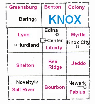
Today
![]()